Geolocalizar

Mapa topográfico Parkgate

Mapa interativo

Clique no mapa para exibir a altitude.

Sobre este mapa

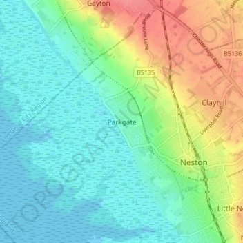
Nome: Mapa topográfico Parkgate, altitude, relevo.

Local: Parkgate, Neston, Cheshire West and Chester, England, CH64 6SR, United Kingdom (53.27719 -3.10362 53.31719 -3.06362)

Altitude média: 22 m

Altitude mínima: -1 m

Altitude máxima: 68 m

Outros mapas topográficos

Clique em um mapa para visualizar sua topografia, sua altitude e seu relevo.

Ness

United Kingdom > England > Cheshire West and Chester > Neston

Ness, Neston, Cheshire West and Chester, England, CH64 4AX, United Kingdom

Altitude média: 34 m

Wirral Country Park

United Kingdom > England > Cheshire West and Chester > Neston > Windle Hill

Wirral Country Park, Hinderton, Windle Hill, Neston, Cheshire West and Chester, England, United Kingdom

Altitude média: 49 m