
Faça uma doação
Mapa topográfico Cary
Clique no mapa para exibir a altitude.
Faça uma doação
Cary
Cary is seated on the boundary between the Durham Basin with its softer sedimentary rocks and the piedmont with its harder metamorphic rocks; both geologic provinces have igneous rock intrusions. The landscape is typically gentle to moderate sloping hills separated by narrow V-shaped valleys, but there are areas with steeper slopes and broader, U-shaped valleys in western Cary, roughly along NC 55 near the Research Triangle Park and north of Green Hope School Road. Cary's average elevation is 495 ft (151 m).
Faça uma doação
Sobre este mapa
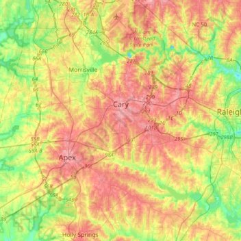
Nome: Mapa topográfico Cary, altitude, relevo.
Local: Cary, Wake County, North Carolina, United States (35.64438 -78.95380 35.89688 -78.72946)
Altitude média: 111 m
Altitude mínima: 60 m
Altitude máxima: 160 m
Faça uma doação
Outros mapas topográficos
Clique em um mapa para visualizar sua topografia, sua altitude e seu relevo.
Lake Raleigh
United States > North Carolina > Wake County > Raleigh > Isle Forest
Altitude média: 104 m
Faça uma doação
Faça uma doação
Faça uma doação
Faça uma doação