
Faça uma doação
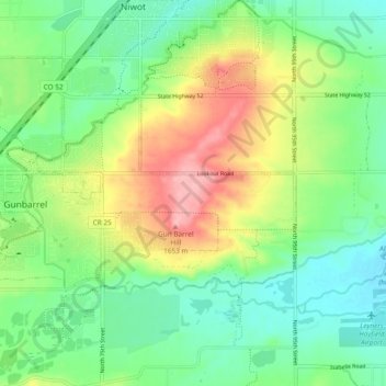
Mapa topográfico Gunbarrel
Clique no mapa para exibir a altitude.
Faça uma doação
Gunbarrel
Gunbarrel is northeast of the city of Boulder proper, separated by a buffer area of private agricultural lands and publicly owned open space. The buffer areas provide over two miles (3 km) of separation over changing elevations.
Faça uma doação
Sobre este mapa
Nome: Mapa topográfico Gunbarrel, altitude, relevo.
Local: Gunbarrel, Boulder County, Colorado, United States (40.05094 -105.22543 40.08707 -105.13112)
Altitude média: 1.585 m
Altitude mínima: 1.543 m
Altitude máxima: 1.654 m
Faça uma doação
Outros mapas topográficos
Clique em um mapa para visualizar sua topografia, sua altitude e seu relevo.
Longs Peak
United States > Colorado > Boulder County
Together with nearby Mount Meeker, with an elevation of 13,911 feet, the two mountains are sometimes referred to as the Twin Peaks (not to be confused with a nearby lower mountain called Twin Sisters).
Altitude média: 3.825 m
Faça uma doação
Faça uma doação
Faça uma doação
South Boulder Canyon Ditch
United States > Colorado > Boulder County > Lafayette
Altitude média: 1.618 m
Faça uma doação
Monument Hill
United States > Colorado > Boulder County
Monument Hill or Black Forest Divide Pass is a 7,352 feet (2,241 m) elevation mountain pass in the Palmer Divide in central Colorado in the United States. The pass dividing the Arkansas River drainage system to the south and the Platte River drainage system to the north is the high point on I-25 between Denver…
Altitude média: 2.315 m
Faça uma doação
Longs Peak
United States > Colorado > Boulder County
Together with nearby Mount Meeker, with an elevation of 13,911 feet, the two mountains are sometimes referred to as the Twin Peaks (not to be confused with a nearby lower mountain called Twin Sisters).
Altitude média: 3.825 m
Nederland
United States > Colorado > Boulder County
In 1873 the Caribou Mine, at an elevation of roughly 10,000 feet (3,000 m) and 6 miles (10 km) northwest of the town, was sold to the Mining Company Nederland from the Netherlands. The high elevation meant fierce winds and deep winter snow, so the new owners of the mine decided that it was beneficial to bring…
Altitude média: 2.578 m
Faça uma doação
National Center for Atmospheric Research
United States > Colorado > Boulder County > Boulder
Altitude média: 1.816 m
Faça uma doação
Boulder
United States > Colorado > Boulder County > Boulder
Boulder is located at the base of the foothills of the Rocky Mountains, at an elevation of 5,430 feet (1,655 m) above sea level. Boulder is 25 miles (40 km) northwest of the Colorado State Capitol in Denver. It is home of the main campus of the University of Colorado, the state's largest university.
Altitude média: 1.977 m
Faça uma doação
Faça uma doação