
Mapa topográfico Saratoga County
Mapa interativo
Clique no mapa para exibir a altitude.
Sobre este mapa
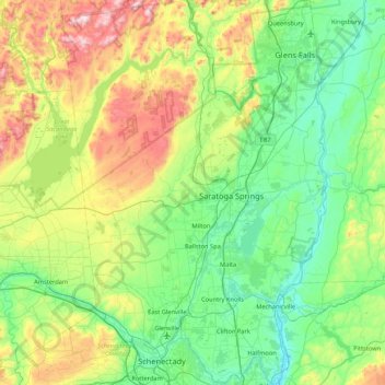
Nome: Mapa topográfico Saratoga County, altitude, relevo.
Local: Saratoga County, New York, USA (42.77546 -74.16010 43.39797 -73.57327)
Altitude média: 218 m
Altitude mínima: 3 m
Altitude máxima: 833 m
Outros mapas topográficos
Clique em um mapa para visualizar sua topografia, sua altitude e seu relevo.
Staten Island
Staten Island, Richmond County, New York, USA
Altitude média: 11 m
Chestnut Creek
Chestnut Creek, Town of Neversink, Sullivan County, New York, 12765, USA
Altitude média: 470 m
Gooseberry Hill
Gooseberry Hill, Essex County, New York, 12872, USA
Altitude média: 304 m
City of Saratoga Springs
USA > New York > City of Saratoga Springs
City of Saratoga Springs, Saratoga County, New York, USA
Altitude média: 95 m
Mount Warren
Mount Warren, Town of Bovina, Delaware County, New York, USA
Altitude média: 677 m
West Bay Shore
USA > New York > West Bay Shore
West Bay Shore, Suffolk County, New York, USA
Altitude média: 7 m
Roosevelt Island
USA > New York > New York City
Roosevelt Island, Manhattan Community Board 8, New York County, New York City, New York, 10044, USA
Altitude média: 13 m
Adirondack
USA > New York > Adirondack
Adirondack, Town of Horicon, Warren County, New York, 12808, USA
Altitude média: 294 m
Big Bear Mountain
Big Bear Mountain, Town of Johnsburg, Warren County, New York, USA
Altitude média: 616 m
Niagara Falls
USA > New York > Niagara Falls
Niagara Falls, Niagara County, New York, USA
Altitude média: 180 m
Avalanche Lake
Avalanche Lake, Avalanche Pass Trail, Essex County, New York, USA
Altitude média: 1.066 m
Livingston Island
Livingston Island, Town of Philipstown, Putnam County, New York, 10922, USA
Altitude média: 156 m