
Mapa topográfico Pagar Alam
Mapa interativo
Clique no mapa para exibir a altitude.
Pagar Alam
Pagar Alam is located by the Bukit Barisan Mountains, at the feet of Mount Dempo. It is situated on the Pasemah Plateau, an extensive fertile highland plain which is surrounded by mountains. It is notable for ancient stone megaliths which surround the town on all sides and are the remnants of a Bronze Age culture. Much of the soil in the city consists of latosol and andisol with rugged and hilly topography. The soil in this city is classified as soil with high fertility (class I).
Sobre este mapa
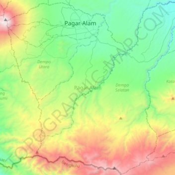
Nome: Mapa topográfico Pagar Alam, altitude, relevo.
Local: Pagar Alam, South Sumatra, Sumatra, Indonesia (-4.26717 103.13002 -3.98478 103.41541)
Altitude média: 1.293 m
Altitude mínima: 443 m
Altitude máxima: 3.151 m
Outros mapas topográficos
Clique em um mapa para visualizar sua topografia, sua altitude e seu relevo.