
Obrigado por apoiar este site ❤️
Faça uma doação
Faça uma doação
Mapa topográfico Mingora
Clique no mapa para exibir a altitude.
Obrigado por apoiar este site ❤️
Faça uma doação
Faça uma doação
Sobre este mapa
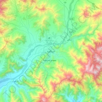
Nome: Mapa topográfico Mingora, altitude, relevo.
Altitude média: 1.385 m
Altitude mínima: 761 m
Altitude máxima: 2.994 m
Obrigado por apoiar este site ❤️
Faça uma doação
Faça uma doação
Outros mapas topográficos
Clique em um mapa para visualizar sua topografia, sua altitude e seu relevo.
Kalam Tehsil
Pakistan > Khyber Pakhtunkhwa > Swat District
At an elevation about 2,000 m (6,600 ft) above sea level, the valley itself provides a plateau that is located above the river and is used for farming. There are a number of visible mountains, also visible from Matiltan, a valley close to Kalam Valley, including Mount Falaksar at 5,918 meters (19,416 feet),…
Altitude média: 3.920 m
Obrigado por apoiar este site ❤️
Faça uma doação
Faça uma doação