
Mapa topográfico Cleveland
Mapa interativo
Clique no mapa para exibir a altitude.
Cleveland
The land rises quickly from the lake shore elevation of 569 feet. Public Square, less than one mile (1.6 km) inland, sits at an elevation of 650 feet (198 m), and Hopkins Airport, 5 miles (8 km) inland from the lake, is at an elevation of 791 feet (241 m).
Sobre este mapa
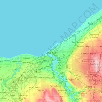
Nome: Mapa topográfico Cleveland, altitude, relevo.
Local: Cleveland, Cuyahoga County, Ohio, 44114, United States (41.34516 -81.85344 41.66516 -81.53344)
Altitude média: 219 m
Altitude mínima: 171 m
Altitude máxima: 385 m