
Obrigado por apoiar este site ❤️
Faça uma doação
Faça uma doação
Mapa topográfico Lamabagar
Clique no mapa para exibir a altitude.
Obrigado por apoiar este site ❤️
Faça uma doação
Faça uma doação
Sobre este mapa
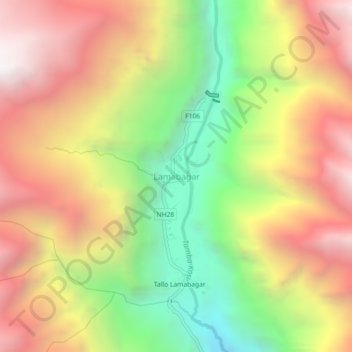
Nome: Mapa topográfico Lamabagar, altitude, relevo.
Local: Lamabagar, Bigu, Dolakha, Bagamati Province, Nepal (27.89537 86.18883 27.93537 86.22883)
Altitude média: 2.714 m
Altitude mínima: 1.662 m
Altitude máxima: 3.700 m
Obrigado por apoiar este site ❤️
Faça uma doação
Faça uma doação
Outros mapas topográficos
Clique em um mapa para visualizar sua topografia, sua altitude e seu relevo.
Obrigado por apoiar este site ❤️
Faça uma doação
Faça uma doação
Tsho Rolpa Lake
Nepal > Bagamati Province > Dolakha
Tsho Rolpa (also Cho Rolpa) is one of the biggest glacial lakes in Nepal. The lake, which is located at an altitude of 4,580 metres (15,030 ft) in the Rolwaling Valley, Dolakha District, has grown considerably over the last 50 years due to glacial melting in the Himalayas.
Altitude média: 4.897 m