
Mapa topográfico Hochstall
Mapa interativo
Clique no mapa para exibir a altitude.
Sobre este mapa
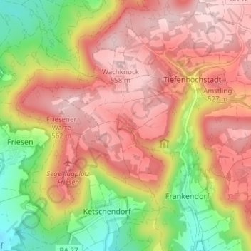
Nome: Mapa topográfico Hochstall, altitude, relevo.
Altitude média: 458 m
Altitude mínima: 312 m
Altitude máxima: 564 m
Outros mapas topográficos
Clique em um mapa para visualizar sua topografia, sua altitude e seu relevo.
Kälberberg
Deutschland > Bayern > Landkreis Bamberg > Tiefenhöchstadt
Kälberberg, Tiefenhöchstadt, Buttenheim, Landkreis Bamberg, Bayern, 96155, Deutschland
Altitude média: 460 m