
Faça uma doação
Mapa topográfico Imphal East District
Clique no mapa para exibir a altitude.
Faça uma doação
Imphal East District
Imphal East District came into existence on 18-06-1997 with its headquarters at Porompat occupying the eastern part of Imphal District. The total area of District is 497 km2. approximately. The District is situated at an altitude 790 metres above the M.S. Level. The climate of the District is salubrious and Monsoon is tropical. The minimum temperature goes down to 0.6 degree Celsius in winter and 41 degree Celsius in summer. It has no rail network and hence communication is entirely dependent on roads except Jiribam District bordering Cachar District of Assam where there is a railhead. As of 2017, A new rail line is under construction and a railway station will be operational by 2019. The District is connected with N.H. 39, N.H. 53 and N.H. 150.
Faça uma doação
Sobre este mapa
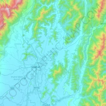
Nome: Mapa topográfico Imphal East District, altitude, relevo.
Local: Imphal East District, Manipur, India (24.65151 93.89542 25.05120 94.13485)
Altitude média: 982 m
Altitude mínima: 767 m
Altitude máxima: 2.498 m
Faça uma doação
Outros mapas topográficos
Clique em um mapa para visualizar sua topografia, sua altitude e seu relevo.