
Mapa topográfico Ballygarrett
Clique no mapa para exibir a altitude.
Sobre este mapa
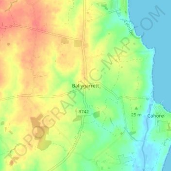
Nome: Mapa topográfico Ballygarrett, altitude, relevo.
Altitude média: 23 m
Altitude mínima: -2 m
Altitude máxima: 48 m
Outros mapas topográficos
Clique em um mapa para visualizar sua topografia, sua altitude e seu relevo.
Taghmon
Ireland > County Wexford > New Ross Municipal District
Many Irish place names are topographically descriptive, and 'Achadh Liathdrom' is no exception. From the western side of the Forth Mountain, as it slopes down towards Ballintlea, a succession of gradual hills and valleys undulate their way across this part of County Wexford towards Camross, Bree and…
Altitude média: 67 m
Ferns
The 19th-century population peaked in 1851, but never reached the levels of medieval times. Lewis's Topography of 1834 claimed the town "consists chiefly of one irregular street, and contains 106 houses indifferently built, retaining no trace of its ancient importance". The Abbey, St.Peter's Church (Catholic…
Altitude média: 53 m
Gorey
The town was granted a charter as a borough in 1619, under the name Newborough. However, as noted in A Topographical Dictionary of Ireland (published in 1837 by Samuel Lewis) and in Wexford Guide and Directory (published by George Henry Bassett in 1885), this name "never [grew] into general use" as the…
Altitude média: 64 m