
Faça uma doação
Mapa topográfico West Chicago
Clique no mapa para exibir a altitude.
Faça uma doação
Sobre este mapa
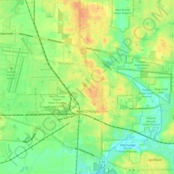
Nome: Mapa topográfico West Chicago, altitude, relevo.
Local: West Chicago, DuPage County, Illinois, 60185, United States (41.85502 -88.26278 41.93726 -88.17515)
Altitude média: 232 m
Altitude mínima: 214 m
Altitude máxima: 252 m
Faça uma doação
Outros mapas topográficos
Clique em um mapa para visualizar sua topografia, sua altitude e seu relevo.
Elmhurst
United States > Illinois > DuPage County
Due to local topography, the town has had a tendency to flood in the past after large rainfalls; the city is currently undertaking a large effort to mitigate future flooding.
Altitude média: 207 m
Elmhurst
United States > Illinois > DuPage County
Due to local topography, the town has had a tendency to flood in the past after large rainfalls; the city is currently undertaking a large effort to mitigate future flooding.
Altitude média: 207 m
Faça uma doação