
Mapa topográfico Newland
Mapa interativo
Clique no mapa para exibir a altitude.
Newland
At an elevation of 3,621 feet or 1,104 metres, it is the highest county seat in the Eastern United States (based on elevations in the USGS database).
Sobre este mapa
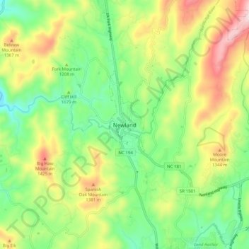
Nome: Mapa topográfico Newland, altitude, relevo.
Local: Newland, Avery County, North Carolina, 28653, United States (36.04735 -81.96734 36.12735 -81.88734)
Altitude média: 1.199 m
Altitude mínima: 987 m
Altitude máxima: 1.535 m