
Faça uma doação
Mapa topográfico Bhimeshwar
Clique no mapa para exibir a altitude.
Faça uma doação
Bhimeshwar
Bhimeshwar, (formerly Charikot), is a municipality in north-eastern Nepal and the headquarters of Dolakha District in Bagmati Province that was established in 1997 by merging the former Village development committees Charikot, Dolakha Town, Makaibari, Mati, Suspaa, and Lankuri danda . At the time of the 2011 Nepal census, it had a population of 32,486 people living in 8,639 individual households. The town is located at an altitude of 1,554 metres (5,101 feet). The name of the district Dolakha came from Dolakha Town situated north-east of the headquarters Charikot Bazaar.
Faça uma doação
Sobre este mapa
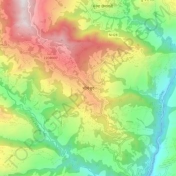
Nome: Mapa topográfico Bhimeshwar, altitude, relevo.
Local: Bhimeshwar, Bhimeshwor, Dolakha, Bagamati Province, Nepal (27.62356 86.00883 27.70356 86.08883)
Altitude média: 1.583 m
Altitude mínima: 843 m
Altitude máxima: 2.626 m
Faça uma doação
Outros mapas topográficos
Clique em um mapa para visualizar sua topografia, sua altitude e seu relevo.
Faça uma doação
Tsho Rolpa Lake
Nepal > Bagamati Province > Dolakha
Tsho Rolpa (also Cho Rolpa) is one of the biggest glacial lakes in Nepal. The lake, which is located at an altitude of 4,580 metres (15,030 ft) in the Rolwaling Valley, Dolakha District, has grown considerably over the last 50 years due to glacial melting in the Himalayas.
Altitude média: 4.897 m