
Mapa topográfico City of Chester
Mapa interativo
Clique no mapa para exibir a altitude.
Sobre este mapa
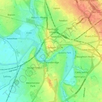
Nome: Mapa topográfico City of Chester, altitude, relevo.
Altitude média: 21 m
Altitude mínima: 2 m
Altitude máxima: 48 m
Outros mapas topográficos
Clique em um mapa para visualizar sua topografia, sua altitude e seu relevo.
Neston
United Kingdom > England > Chester
Neston, Chester, Cheshire West and Chester, North West England, England, CH64 9UY, United Kingdom
Altitude média: 32 m
Liverpool Bay
United Kingdom > England > Chester
Liverpool Bay, Chester, Cheshire West and Chester, North West England, England, United Kingdom
Altitude média: 0 m
Wych Brook
United Kingdom > England > Chester
Wych Brook, Chester, Cheshire West and Chester, North West England, England, SY14 7NG, United Kingdom
Altitude média: 72 m