Geolocalizar

Mapa topográfico Nuneaton

Mapa interativo

Clique no mapa para exibir a altitude.

Sobre este mapa

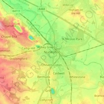
Nome: Mapa topográfico Nuneaton, altitude, relevo.

Local: Nuneaton, Nuneaton and Bedworth, Warwickshire, England, CV11 5AB, United Kingdom (52.48462 -1.50845 52.56462 -1.42845)

Altitude média: 101 m

Altitude mínima: 39 m

Altitude máxima: 172 m

Outros mapas topográficos

Clique em um mapa para visualizar sua topografia, sua altitude e seu relevo.

Nuneaton Common

United Kingdom > England > Warwickshire > Nuneaton and Bedworth

Nuneaton Common, Whittleford, Nuneaton and Bedworth, Warwickshire, England, United Kingdom

Altitude média: 127 m

Ash Green

United Kingdom > England > Warwickshire > Nuneaton and Bedworth > Ash Green

Ash Green, Nuneaton and Bedworth, Warwickshire, England, CV7 9AQ, United Kingdom

Altitude média: 111 m

Horeston Grange

United Kingdom > England > Warwickshire > Nuneaton and Bedworth

Horeston Grange, Nuneaton and Bedworth, Warwickshire, England, CV11 6YL, United Kingdom

Altitude média: 90 m

Exhall

United Kingdom > England > Warwickshire > Nuneaton and Bedworth

Exhall, Nuneaton and Bedworth, Warwickshire, England, CV7 9DJ, United Kingdom

Altitude média: 101 m

Bedworth

United Kingdom > England > Warwickshire > Nuneaton and Bedworth

Bedworth, Nuneaton and Bedworth, Warwickshire, England, CV12 9DQ, United Kingdom

Altitude média: 105 m

Bulkington

United Kingdom > England > Warwickshire > Nuneaton and Bedworth

Bulkington, Nuneaton and Bedworth, Warwickshire, England, CV12 9NN, United Kingdom

Altitude média: 107 m