
Mapa topográfico Pine Valley Mountain Wilderness
Mapa interativo
Clique no mapa para exibir a altitude.
Sobre este mapa
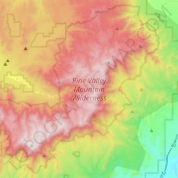
Nome: Mapa topográfico Pine Valley Mountain Wilderness, altitude, relevo.
Altitude média: 2.125 m
Altitude mínima: 1.117 m
Altitude máxima: 3.147 m
Pine Valley Mountain Wilderness is a 50,232-acre (203.28 km2) wilderness area located in the Dixie National Forest in the U.S. state of Utah. It is the fourth-largest wilderness area located entirely within the state (following the High Uintas Wilderness, Zion Wilderness, and Cedar Mountain Wilderness). The wilderness designation protects the Pine Valley Mountain range, a large rock outcrop surrounded by desert. The Pine Valley Mountains form the Pine Valley Laccolith, one of the largest laccoliths in the United States. Elevations in the wilderness range from 6,000 feet (1,800 m) to 10,365 feet (3,159 m) at the summit of Signal Peak.
Outros mapas topográficos
Clique em um mapa para visualizar sua topografia, sua altitude e seu relevo.
Virgin
United States > Utah > Washington County
Virgin, Washington County, Utah, United States
Altitude média: 1.251 m
Springdale
United States > Utah > Washington County
Springdale, Washington County, Utah, 84767, United States
Altitude média: 1.354 m
Saint George
United States > Utah > Washington County
Saint George, Washington County, Utah, United States
Altitude média: 929 m
Cottonwood Canyon Wilderness
United States > Utah > Washington County > Washington
Cottonwood Canyon Wilderness, Washington, Washington County, Utah, United States
Altitude média: 1.213 m
Toquerville
United States > Utah > Washington County
Toquerville, Washington County, Utah, 84774, United States
Altitude média: 1.301 m
Hurricane
United States > Utah > Washington County
Hurricane, Washington County, Utah, United States
Altitude média: 1.154 m
Ivins
United States > Utah > Washington County > Ivins
Ivins, Washington County, Utah, 84738, United States
Altitude média: 1.007 m
Zion National Park
United States > Utah > Washington County
Zion National Park, Washington County, Utah, United States
Altitude média: 1.877 m