
Mapa topográfico Drummore
Mapa interativo
Clique no mapa para exibir a altitude.
Sobre este mapa
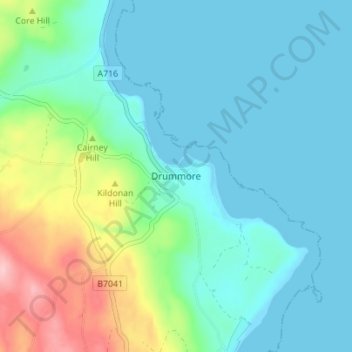
Nome: Mapa topográfico Drummore, altitude, relevo.
Altitude média: 36 m
Altitude mínima: 0 m
Altitude máxima: 161 m
Outros mapas topográficos
Clique em um mapa para visualizar sua topografia, sua altitude e seu relevo.
Sanquhar
United Kingdom > Scotland > Dumfries and Galloway
Sanquhar, Dumfries and Galloway, Scotland, DG4 6DJ, United Kingdom
Altitude média: 243 m
Gillesbie
United Kingdom > Scotland > Dumfries and Galloway > Boreland
Gillesbie, Boreland, Dumfries and Galloway, Scotland, DG11 2LF, United Kingdom
Altitude média: 195 m
Holywood
United Kingdom > Scotland > Dumfries and Galloway
Holywood, Dumfries and Galloway, Scotland, DG2 0RE, United Kingdom
Altitude média: 26 m
Lockerbie
United Kingdom > Scotland > Dumfries and Galloway
Lockerbie, Dumfries and Galloway, Scotland, DG11 2EU, United Kingdom
Altitude média: 96 m
Ley Hill
United Kingdom > Scotland > Dumfries and Galloway
Ley Hill, Dumfries and Galloway, Scotland, DG11 3HG, United Kingdom
Altitude média: 214 m
Cairnryan
United Kingdom > Scotland > Dumfries and Galloway > Cairnryan
Cairnryan, Dumfries and Galloway, Scotland, DG9 8RB, United Kingdom
Altitude média: 64 m