
Faça uma doação
Mapa topográfico Enchanted Rock
Clique no mapa para exibir a altitude.
Faça uma doação
Enchanted Rock
Enchanted Rock is a pink granite mountain located in the Llano Uplift about 17 miles (27 km) north of Fredericksburg, Texas and 24 miles (39 km) south of Llano, Texas, United States. Enchanted Rock State Natural Area, which includes Enchanted Rock and surrounding land, spans the border between Gillespie and Llano counties, south of the Llano River. Enchanted Rock covers roughly 640 acres (260 ha) and rises around 425 feet (130 m) above the surrounding terrain to an elevation of 1,825 feet (556 m) above sea level. It is the largest pink granite monadnock in the United States. Enchanted Rock State Natural Area, a part of the Texas state park system, includes 1,644 acres (665 ha). In 1936, the area was designated a Recorded Texas Historic Landmark. In 1971, Enchanted Rock was designated as a National Natural Landmark by the National Park Service.
Faça uma doação
Sobre este mapa
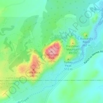
Nome: Mapa topográfico Enchanted Rock, altitude, relevo.
Local: Enchanted Rock, Llano County, Texas, United States (30.50642 -98.81885 30.50652 -98.81875)
Altitude média: 453 m
Altitude mínima: 414 m
Altitude máxima: 554 m
Faça uma doação
Outros mapas topográficos
Clique em um mapa para visualizar sua topografia, sua altitude e seu relevo.