
Mapa topográfico Todtnau
Clique no mapa para exibir a altitude.
Sobre este mapa
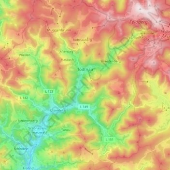
Nome: Mapa topográfico Todtnau, altitude, relevo.
Local: Todtnau, Landkreis Lörrach, Baden-Württemberg, 79674, Germany (47.75734 7.88634 47.88031 8.02241)
Altitude média: 987 m
Altitude mínima: 499 m
Altitude máxima: 1.494 m
Outros mapas topográficos
Clique em um mapa para visualizar sua topografia, sua altitude e seu relevo.
Blauen
Germany > Baden-Württemberg > Landkreis Lörrach
In the 14th century, the mountain was recorded as the Blauwen or Blawen. Matthäus Merian's Topographia Sueviae in the mid-17th century calls it the Hoche Blawen ("High Blawen"). The parish boundary plan of the first Baden state survey of 1769/1770 distinguishes between the Hoch Blauen ("High Blauen") and the…
Altitude média: 877 m
Nordschwaben
Germany > Baden-Württemberg > Landkreis Lörrach > Rheinfelden (Baden)
Altitude média: 446 m
Obertüllingen
Germany > Baden-Württemberg > Landkreis Lörrach > Lörrach > Untertüllingen
Altitude média: 307 m
Elbenschwand
Germany > Baden-Württemberg > Landkreis Lörrach > Kleines Wiesental
Altitude média: 789 m