
Faça uma doação
Mapa topográfico Windhoek
Clique no mapa para exibir a altitude.
Faça uma doação
Windhoek
Windhoek has over 300 sunny days per year. It experiences a hot semi-arid climate (BSh) according to Köppen climate classification as the annual average temperature is above 18 °C (64 °F). The temperature throughout the year would be called mild, due to altitude influence. The annual average high and low temperature range is 13.4 °C (24.1 °F). The coldest month is July, with an average temperature of 13.1 °C (55.6 °F), while the hottest month is December, with average temperature 23.5 °C (74.3 °F). Due to its location near the Kalahari Desert, the city receives 3,605 hours of sunshine. Precipitation is abundant during the summer season, and minimal during the winter season. The average annual precipitation is 367.4 mm (14.46 in), with lows of 106.7 mm (4.20 in) in the 2018/19 rainy season, and 97 mm (3.8 in) in 1929/30.
Faça uma doação
Sobre este mapa
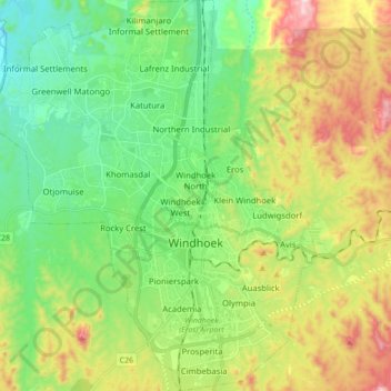
Nome: Mapa topográfico Windhoek, altitude, relevo.
Local: Windhoek, Khomas, Namibia (-22.63866 16.98687 -22.42857 17.13062)
Altitude média: 1.710 m
Altitude mínima: 1.442 m
Altitude máxima: 2.172 m
Faça uma doação
Outros mapas topográficos
Clique em um mapa para visualizar sua topografia, sua altitude e seu relevo.
Windhoek
Windhoek has over 300 sunny days per year. It experiences a hot semi-arid climate (BSh) according to Köppen climate classification as the annual average temperature is above 18 °C (64 °F). The temperature throughout the year would be called mild, due to altitude influence. The annual average high and low…
Altitude média: 1.709 m