
Faça uma doação
Mapa topográfico Tarqui
Clique no mapa para exibir a altitude.
Faça uma doação
Tarqui
Coordinates: 3°00′49″S 79°02′04″W; Official Language: Spanish; Entity: Parish of Ecuador; Province: Azuay; Canton: Cuenca; President of the Parish Government: Galo Zhagüi; Subdivisions: 26 communities; Foundation and Parishization: October 18, 1915 (108 years old); Area: 135 km²; Average Altitude: 2628 m above. n. m.; Climate: Average annual temperatures of 12 °C to 20 °C; Watercourse: Tarqui River; Population (2010): 12,490 inhabitants, Density: 92.52 inhabitants/km²; Time Zone: ECT (UTC-5); Postal Code EC010168.
Faça uma doação
Sobre este mapa
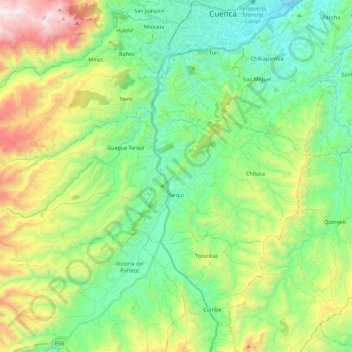
Nome: Mapa topográfico Tarqui, altitude, relevo.
Local: Tarqui, Cuenca, Azuay, Ecuador (-3.04606 -79.17633 -2.95740 -78.95060)
Altitude média: 2.875 m
Altitude mínima: 2.436 m
Altitude máxima: 3.852 m
Faça uma doação
Outros mapas topográficos
Clique em um mapa para visualizar sua topografia, sua altitude e seu relevo.
Cuenca
Cuenca, officially Santa Ana de los Ríos de Cuenca, is an Ecuadorian city, head of the canton of the same name and capital of the province of Azuay, as well as its largest and most populated city. It is crossed by the Tomebamba, Tarqui, Yanuncay and Machángara rivers, in the south-central inter-Andean region…
Altitude média: 2.973 m
Faça uma doação