
Faça uma doação
Mapa topográfico Fars Province
Clique no mapa para exibir a altitude.
Faça uma doação
Sobre este mapa
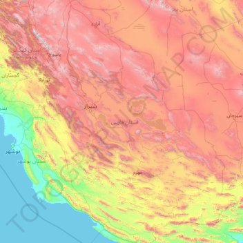
Nome: Mapa topográfico Fars Province, altitude, relevo.
Local: Fars Province, Iran (27.06802 50.60318 31.66964 55.73296)
Altitude média: 1.339 m
Altitude mínima: -2 m
Altitude máxima: 4.174 m
Faça uma doação
Outros mapas topográficos
Clique em um mapa para visualizar sua topografia, sua altitude e seu relevo.
Amlash
Iran > Gilan Province > Amlash County > دهستان املش شمالی
Amlash (Persian: املش) is a city in the Central District of Amlash County, Gilan province, in northwestern Iran, serving as the capital of both the county and the district. Amlash sits at an altitude of 13 metres (45 feet).
Altitude média: 66 m
Faça uma doação
Faça uma doação
Faça uma doação
Faça uma doação
Faça uma doação
Sabalan
Iran > Ardabil Province > Meshkinshahr County > دهستان لاهرود
At 4,794 metres (15,728 ft) in elevation, it is the third-highest mountain in Iran. It has a permanent crater lake formed at its summit. On one of its slopes around 3,600 metres (11,800 ft) in elevation there are large rock formations of eroded volcanic outcrops that resemble animals, birds, and insects.
Altitude média: 4.281 m
Faça uma doação
Beynaq, Razavi Khorasan
Iran > East Azerbaijan Province > Ahar County > دهستان اوچ هاچا > Beynaq, Razavi Khorasan
Altitude média: 1.599 m
Faça uma doação
Qinarjeh, Takab
Iran > West Azerbaijan Province > Takab County > Qinarjeh, Takab
Altitude média: 2.334 m
Zard Kuh
Iran > Chaharmahal and Bakhtiyari Province > Kuhrang County > شهریاری
Altitude média: 3.808 m
Faça uma doação
Faça uma doação