
Faça uma doação
Mapa topográfico savannakhet
Clique no mapa para exibir a altitude.
Faça uma doação
Sobre este mapa
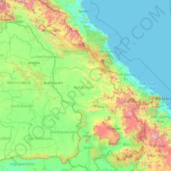
Nome: Mapa topográfico savannakhet, altitude, relevo.
Local: savannakhet, Laos (13.94337 103.16035 19.14337 108.36035)
Altitude média: 273 m
Altitude mínima: -1 m
Altitude máxima: 2.629 m
Faça uma doação
Outros mapas topográficos
Clique em um mapa para visualizar sua topografia, sua altitude e seu relevo.
Luang Namtha
The Nam Ha National Biodiversity Conservation Area (NBCA) has dense forest covering 90% of the area. May to September are the rainy months with average annual rainfall of 1,256 millimetres (49.4 in). December to February are the winter months with temperatures touching as low as 5 °C (41 °F). Heavy fog is…
Altitude média: 861 m
Luang Prabang
The 60,070 hectare Phou Louey Massif Important Bird Area (IBA) is in the Nam Et-Phou Louey National Biodiversity Conservation Area (NBCA). The IBA is in the provinces of Luang Prabang and Houaphanh. It sits at an elevation of 700–1,800 metres (2,300–5,900 ft). The habitat contains mixed deciduous forest,…
Altitude média: 910 m
Champasak Province
The Mekong Channel from Phou Xiang Thong to Siphandon Important Bird Area (IBA) is 34,200 ha (85,000 acres) in size. A portion of the IBA (10,000 hectares) overlaps with the 120,000 ha (300,000 acres) Phou Xieng Thong National Protected Area. The IBA encompasses two provinces, Champasak and Salavan. The IBA is…
Altitude média: 262 m
Faça uma doação
Golden Triangle Special Economic Zone
Laos > Bokeo Province > Tonpheung District
Altitude média: 407 m
Sekong Province
The Dakchung Plateau is an Important Bird Area (IBA). It is 5,140 ha in size, and at an elevation of 800–1,400 metres (2,600–4,600 ft). The habitat is characterized as pine woodland, grassland, degraded semi-evergreen forest, dry evergreen forest, marshy land, and tall grasses areas. Of the avifauna, the…
Altitude média: 771 m
Faça uma doação