
Obrigado por apoiar este site ❤️
Faça uma doação
Faça uma doação
Mapa topográfico Altenberg bei Linz
Clique no mapa para exibir a altitude.
Obrigado por apoiar este site ❤️
Faça uma doação
Faça uma doação
Altenberg bei Linz
Located on a southern part of the Zentralmühlviertler Hochland [de] at an altitude of 592 meters, the municipality has a view over the Mühlviertel region, Linz, the capital of Upper Austria as well as the so-called Zentralland and even the foothills of the Northern Limestone Alps. Because of that, it has been described as the "Balcony of Linz".
Obrigado por apoiar este site ❤️
Faça uma doação
Faça uma doação
Sobre este mapa
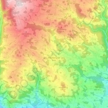
Nome: Mapa topográfico Altenberg bei Linz, altitude, relevo.
Altitude média: 573 m
Altitude mínima: 317 m
Altitude máxima: 843 m
Obrigado por apoiar este site ❤️
Faça uma doação
Faça uma doação
Outros mapas topográficos
Clique em um mapa para visualizar sua topografia, sua altitude e seu relevo.