
Mapa topográfico Cantabria
Mapa interativo
Clique no mapa para exibir a altitude.
Cantabria
Towards the south are higher mountains, the tops of which form the watershed between the drainage basins of the Rivers Ebro, Duero and the rivers that flow into the Bay of Biscay. These peaks generally exceed 1,500 m (4,900 ft) from the Pass of San Glorio in the west to the Pass of Los Tornos in the eastern part: Peña Labra, Castro Valnera and the mountain passes of Sejos, El Escudo and La Sía. The great limestone masses of Picos de Europa also stand out in the southwest of the region: most of their summits exceed 2,500 m (8,200 ft), and their topography is shaped by the former presence of glaciers.
Sobre este mapa
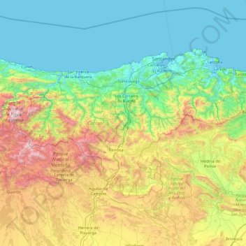
Nome: Mapa topográfico Cantabria, altitude, relevo.
Local: Cantabria, Spain (42.75805 -4.85174 43.51362 -3.14965)
Altitude média: 609 m
Altitude mínima: -3 m
Altitude máxima: 2.603 m
Outros mapas topográficos
Clique em um mapa para visualizar sua topografia, sua altitude e seu relevo.
Napal
Spain > Navarre > Zangozerria / Comarca de Sangüesa > Romanzado/Erromantzatua
Altitude média: 710 m
Parque Alcalde José Sánchez
Spain > Campo de Cartagena y Mar Menor > San Pedro del Pinatar > Los Peñascos
Altitude média: 7 m
Piedra del Águila
Spain > Andalusia > Comarca de Huéscar > Puebla de Don Fadrique
Altitude média: 1.295 m
Muleta
Spain > Aragon > Matarraña / Matarranya > Valderrobres / Vall de Roures
Altitude média: 1.131 m
Santiago de Compostela
The cathedral borders the main plaza of the old and well-preserved city. According to medieval legend, the remains of the apostle James were brought to Galicia for burial; in 813, the light of a bright star guided a shepherd who was watching his flock at night to the burial site in Santiago de Compostela. This…
Altitude média: 248 m
Soil
Spain > Autonomous Community of the Basque Country > Montaña Alavesa/Arabako Mendialdea
Altitude média: 898 m