
Mapa topográfico Bernbeuren
Mapa interativo
Clique no mapa para exibir a altitude.
Sobre este mapa
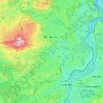
Nome: Mapa topográfico Bernbeuren, altitude, relevo.
Altitude média: 789 m
Altitude mínima: 694 m
Altitude máxima: 1.047 m
Outros mapas topográficos
Clique em um mapa para visualizar sua topografia, sua altitude e seu relevo.
Fischen
Deutschland > Bayern > Landkreis Weilheim-Schongau
Fischen, Pähl, Landkreis Weilheim-Schongau, Bayern, 82396, Deutschland
Altitude média: 577 m