
Faça uma doação
Mapa topográfico Bald Mountain
Clique no mapa para exibir a altitude.
Faça uma doação
Sobre este mapa
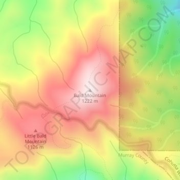
Nome: Mapa topográfico Bald Mountain, altitude, relevo.
Local: Bald Mountain, Murray County, Georgia, United States (34.86445 -84.62836 34.86455 -84.62826)
Altitude média: 986 m
Altitude mínima: 685 m
Altitude máxima: 1.212 m
Faça uma doação
Outros mapas topográficos
Clique em um mapa para visualizar sua topografia, sua altitude e seu relevo.
Chatsworth
United States > Georgia > Murray County
Chatsworth is located in central Murray County at 34°46′20″N 84°46′44″W / 34.77222°N 84.77889°W / 34.77222; -84.77889 (34.772336, -84.778977), in northwestern Georgia. It sits at an elevation of 750 feet (230 m) on the west side of the valley of Holly Creek, with 2,840-foot (870 m) Fort…
Altitude média: 241 m