

Mapa topográfico Calw
Clique no mapa para exibir a altitude.
Calw
Calw is located in the valley of the Nagold in the Northern Black Forest at an altitude between 330 and 630 metres (1,080–2,070 ft) above sea level. The historic centre lies west of the river. The newer parts of town have developed on the surrounding slopes. The following streams also exist within the town: the Tälesbach, Ziegelbach, Wurstbrunnenbach, Schießbach, Schlittenbach und Schweinbach. In the northern part of the town, on the western slope of the Nagold valley is the cave known as the Bruderhöhle.
Sobre este mapa
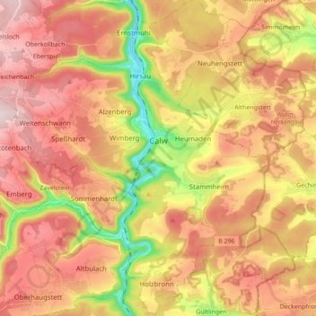
Nome: Mapa topográfico Calw, altitude, relevo.
Altitude média: 540 m
Altitude mínima: 324 m
Altitude máxima: 701 m
Outros mapas topográficos
Clique em um mapa para visualizar sua topografia, sua altitude e seu relevo.


Zieflensberg
Germany > Baden-Württemberg > Landkreis Calw > Bad Herrenalb > Zieflensberg
Altitude média: 668 m
Bad Teinach
Germany > Baden-Württemberg > Landkreis Calw
The township (Stadt) of Bad Teinach-Zavelstein is located at the center of the district of Calw, in Baden-Württemberg, one of the 16 States of the Federal Republic of Germany. Bad Teinach-Zavelstein's municipal area rests upon the plateau of the Enz and Nagold rivers, a landscape defined by severe river…
Altitude média: 557 m