
Faça uma doação
Mapa topográfico Brady Lake
Clique no mapa para exibir a altitude.
Faça uma doação
Sobre este mapa
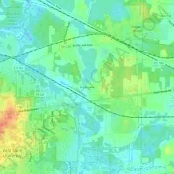
Nome: Mapa topográfico Brady Lake, altitude, relevo.
Altitude média: 328 m
Altitude mínima: 312 m
Altitude máxima: 363 m
Faça uma doação
Outros mapas topográficos
Clique em um mapa para visualizar sua topografia, sua altitude e seu relevo.
Kent
United States > Ohio > Portage County
Located on the western end of the Glaciated Allegheny Plateau, the topography of Kent includes rolling hills and varied terrain. The Cuyahoga River passes through the city, cutting a gorge with a drop of nearly 40 feet (10 m) adjacent to the downtown area. The United States Geological Survey lists the city's…
Altitude média: 328 m
Faça uma doação
Faça uma doação
Faça uma doação
Kent
United States > Ohio > Portage County
Located on the western end of the Glaciated Allegheny Plateau, the topography of Kent includes rolling hills and varied terrain. The Cuyahoga River passes through the city, cutting a gorge with a drop of nearly 40 feet (10 m) adjacent to the downtown area. The United States Geological Survey lists the city's…
Altitude média: 328 m
Faça uma doação