
Faça uma doação
Mapa topográfico Spring Hill
Clique no mapa para exibir a altitude.
Faça uma doação
Sobre este mapa
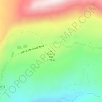
Nome: Mapa topográfico Spring Hill, altitude, relevo.
Local: Spring Hill, Sanpete County, Utah, United States (39.15047 -111.56274 39.15057 -111.56264)
Altitude média: 2.746 m
Altitude mínima: 2.408 m
Altitude máxima: 3.227 m
Faça uma doação
Outros mapas topográficos
Clique em um mapa para visualizar sua topografia, sua altitude e seu relevo.
Manti
United States > Utah > Sanpete County
Manti has a humid continental climate (Köppen Dfb) with warm summers and cold winters, receiving on average barely enough rainfall to avoid a semi-arid classification (BSk). Its high elevation means that the climate is cooler than other populated areas of Utah, especially during summer. Summers highs average…
Altitude média: 1.743 m
Faça uma doação
Manti
United States > Utah > Sanpete County
Manti has a humid continental climate (Köppen Dfb) with warm summers and cold winters, receiving on average barely enough rainfall to avoid a semi-arid classification (BSk). Its high elevation means that the climate is cooler than other populated areas of Utah, especially during summer. Summers highs average…
Altitude média: 1.743 m