
Mapa topográfico Yantai
Mapa interativo
Clique no mapa para exibir a altitude.
Sobre este mapa
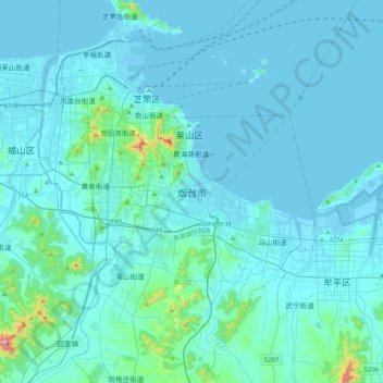
Nome: Mapa topográfico Yantai, altitude, relevo.
Altitude média: 34 m
Altitude mínima: -3 m
Altitude máxima: 546 m
Yantai is located along the north coast of the Shandong Peninsula, south of the junction of Bohai Sea and Yellow Sea and parallel to the southern coast of Liaoning. The topographical breakdown consists of:
Outros mapas topográficos
Clique em um mapa para visualizar sua topografia, sua altitude e seu relevo.