
Faça uma doação
Mapa topográfico Folsom
Clique no mapa para exibir a altitude.
Faça uma doação
Folsom
Carpenter Hill in Folsom has the highest elevation in Sacramento County, at 831 feet (253 meters).
Faça uma doação
Sobre este mapa
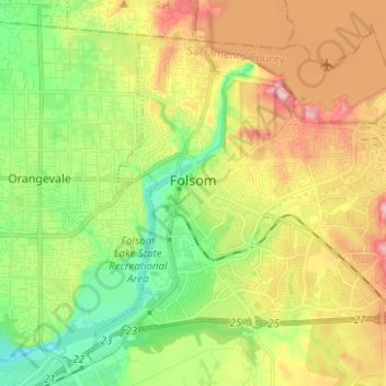
Nome: Mapa topográfico Folsom, altitude, relevo.
Local: Folsom, Sacramento County, California, United States (38.61044 -121.21010 38.71736 -121.07908)
Altitude média: 90 m
Altitude mínima: 21 m
Altitude máxima: 217 m
Faça uma doação
Outros mapas topográficos
Clique em um mapa para visualizar sua topografia, sua altitude e seu relevo.
Faça uma doação
Faça uma doação
Faça uma doação
Walnut Grove
United States > California > Sacramento County
Walnut Grove's location has made it the site of a rare collection of very tall radio and television transmission towers. The first major tower here was the KXTV/KOVR/KCRA Tower built in 1962, which dominated the skyline for over twenty years with its 1,548 foot height. In 1985 the old tower was joined by…
Altitude média: 1 m
Faça uma doação
Faça uma doação
Faça uma doação
Faça uma doação
Faça uma doação
Faça uma doação