
Mapa topográfico Dwight
Mapa interativo
Clique no mapa para exibir a altitude.
Sobre este mapa
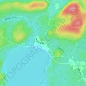
Nome: Mapa topográfico Dwight, altitude, relevo.
Altitude média: 341 m
Altitude mínima: 309 m
Altitude máxima: 427 m
Outros mapas topográficos
Clique em um mapa para visualizar sua topografia, sua altitude e seu relevo.
Limberlost Forest and Wildlife Reserve
Canada > Ontario > Muskoka District > Lake of Bays Township
Limberlost Forest and Wildlife Reserve, Lake of Bays Township, District Municipality of Muskoka, Muskoka District, Central Ontario, Ontario, Canada
Altitude média: 400 m
Tackaberry Lake
Canada > Ontario > Muskoka District > Lake of Bays Township
Tackaberry Lake, Lake of Bays Township, District Municipality of Muskoka, Muskoka District, Central Ontario, Ontario, Canada
Altitude média: 338 m
Oxbow Lake
Canada > Ontario > Muskoka District > Lake of Bays Township
Oxbow Lake, Lake of Bays Township, District Municipality of Muskoka, Muskoka District, Central Ontario, Ontario, Canada
Altitude média: 400 m