
Mapa topográfico Cordemois
Mapa interativo
Clique no mapa para exibir a altitude.
Sobre este mapa
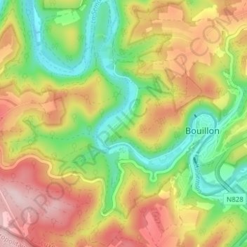
Nome: Mapa topográfico Cordemois, altitude, relevo.
Altitude média: 312 m
Altitude mínima: 197 m
Altitude máxima: 443 m
Outros mapas topográficos
Clique em um mapa para visualizar sua topografia, sua altitude e seu relevo.
Corbion
Belgique > Luxembourg > Neufchâteau > Bouillon
Corbion, Bouillon, Neufchâteau, Luxembourg, Wallonie, 6838, Belgique
Altitude média: 344 m
Le Tombeau du Géant
Belgique > Luxembourg > Neufchâteau > Bouillon > Ucimont > Botassart
Le Tombeau du Géant, Moulin du Rivage, Botassart, Ucimont, Bouillon, Neufchâteau, Luxembourg, Wallonie, 6833, Belgique
Altitude média: 300 m
Sensenruth
Belgique > Luxembourg > Neufchâteau > Bouillon
Sensenruth, Bouillon, Neufchâteau, Luxembourg, Wallonie, 6832, Belgique
Altitude média: 358 m
Bouillon
Belgique > Luxembourg > Neufchâteau > Bouillon
Bouillon, Neufchâteau, Luxembourg, Wallonie, 6830, Belgique
Altitude média: 338 m
Frahan
Belgique > Luxembourg > Neufchâteau > Bouillon > Rochehaut
Frahan, Rochehaut, Bouillon, Neufchâteau, Luxembourg, Wallonie, 6838, Belgique
Altitude média: 291 m
Rochehaut
Belgique > Luxembourg > Neufchâteau > Bouillon
Rochehaut, Bouillon, Neufchâteau, Luxembourg, Wallonie, Belgique
Altitude média: 296 m
Dohan
Belgique > Luxembourg > Neufchâteau > Bouillon
Dohan, Bouillon, Neufchâteau, Luxembourg, Wallonie, Belgique
Altitude média: 284 m
Curfoz
Belgique > Luxembourg > Neufchâteau > Bouillon
Curfoz, Bouillon, Neufchâteau, Luxembourg, Wallonie, 6831, Belgique
Altitude média: 344 m
Briahan
Belgique > Luxembourg > Neufchâteau > Bouillon
Briahan, Sensenruth, Bouillon, Neufchâteau, Luxembourg, Wallonie, 6832, Belgique
Altitude média: 363 m