
Faça uma doação
Mapa topográfico Nigüelas
Clique no mapa para exibir a altitude.
Faça uma doação
Sobre este mapa
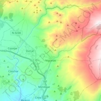
Nome: Mapa topográfico Nigüelas, altitude, relevo.
Altitude média: 1.212 m
Altitude mínima: 508 m
Altitude máxima: 2.449 m
Faça uma doação
Outros mapas topográficos
Clique em um mapa para visualizar sua topografia, sua altitude e seu relevo.
Alhambra
Spain > Andalusia > Partido Judicial de Granada > Granada
During the reign of the Nasrid Dynasty, the Alhambra was transformed into a palatine city, complete with an irrigation system composed of aqueducts and water channels that provided water for the complex and for other nearby countryside palaces such as the Generalife. Previously, the old fortresses on the hill…
Altitude média: 759 m