
Mapa topográfico Mountain Top
Mapa interativo
Clique no mapa para exibir a altitude.
Sobre este mapa
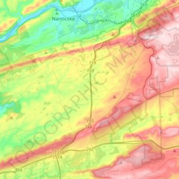
Nome: Mapa topográfico Mountain Top, altitude, relevo.
Altitude média: 371 m
Altitude mínima: 150 m
Altitude máxima: 644 m
The elevation within the Mountain Top CDP ranges from 1,070 feet (330 m) above sea level along Big Wapwallopen Creek in the southwest, to 1,860 feet (570 m) atop Nescopeck Mountain southwest of Rita, to 1,871 feet (570 m) at the east end of Penobscot Mountain in the north of the CDP. The central village of Mountain Top sits at 1,580 feet (480 m) just south of Penobscot Mountain.
Outros mapas topográficos
Clique em um mapa para visualizar sua topografia, sua altitude e seu relevo.
Stairville
United States > Pennsylvania > Luzerne County > Dorrance Township
Stairville, Dorrance Township, Luzerne County, Pennsylvania, 18660, United States
Altitude média: 332 m