
Mapa topográfico Untersiemau
Mapa interativo
Clique no mapa para exibir a altitude.
Sobre este mapa
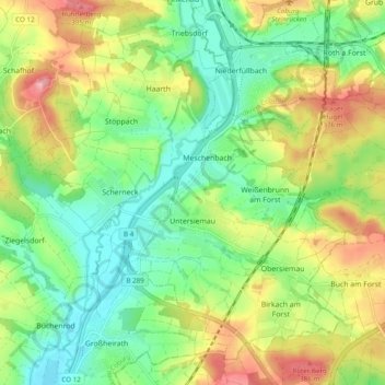
Nome: Mapa topográfico Untersiemau, altitude, relevo.
Local: Untersiemau, Landkreis Coburg, Bayern, 96253, Deutschland (50.17322 10.91416 50.22707 11.01104)
Altitude média: 319 m
Altitude mínima: 264 m
Altitude máxima: 405 m
Untersiemau liegt am Ostrand des Itzgrunds etwa zehn Kilometer südlich von Coburg auf einer Höhe von etwa 300 Metern. Östlich des Ortes erstreckt sich der Lichtenfelser Forst.
Outros mapas topográficos
Clique em um mapa para visualizar sua topografia, sua altitude e seu relevo.
Heldritt
Deutschland > Bayern > Landkreis Coburg > Bad Rodach
Heldritt, Bad Rodach, Landkreis Coburg, Bayern, 96476, Deutschland
Altitude média: 374 m
Sonnefeld
Deutschland > Bayern > Landkreis Coburg
Sonnefeld, Landkreis Coburg, Bayern, 96242, Deutschland
Altitude média: 354 m
Ahlstadt
Deutschland > Bayern > Landkreis Coburg
Ahlstadt, Meeder, Landkreis Coburg, Bayern, Deutschland
Altitude média: 435 m
Kleingarnstadt
Deutschland > Bayern > Landkreis Coburg
Kleingarnstadt, Ebersdorf b.Coburg, Landkreis Coburg, Bayern, Deutschland
Altitude média: 385 m
Hattersdorf
Deutschland > Bayern > Landkreis Coburg > Seßlach
Hattersdorf, Seßlach, Landkreis Coburg, Bayern, 96145, Deutschland
Altitude média: 300 m
Bad Rodach
Deutschland > Bayern > Landkreis Coburg
Bad Rodach, Landkreis Coburg, Bayern, 96476, Deutschland
Altitude média: 352 m
Ahorn
Deutschland > Bayern > Landkreis Coburg
Ahorn, Landkreis Coburg, Bayern, 96482, Deutschland
Altitude média: 333 m
Rödental
Deutschland > Bayern > Landkreis Coburg
Rödental, Landkreis Coburg, Bayern, 96472, Deutschland
Altitude média: 381 m
Neustadt bei Coburg
Deutschland > Bayern > Landkreis Coburg
Neustadt bei Coburg, Landkreis Coburg, Bayern, 96465, Deutschland
Altitude média: 372 m
Ebersdorf b.Coburg
Deutschland > Bayern > Landkreis Coburg
Ebersdorf b.Coburg, Landkreis Coburg, Bayern, 96237, Deutschland
Altitude média: 351 m
Hassenberg
Deutschland > Bayern > Landkreis Coburg > Hassenberg
Hassenberg, Sonnefeld, Landkreis Coburg, Bayern, 96268, Deutschland
Altitude média: 338 m
Scherneck
Deutschland > Bayern > Landkreis Coburg
Scherneck, Untersiemau, Landkreis Coburg, Bayern, 96253, Deutschland
Altitude média: 307 m
Grub am Forst
Deutschland > Bayern > Landkreis Coburg > Grub a.Forst > Grub am Forst
Grub am Forst, Grub a.Forst, Grub am Forst (VGem), Landkreis Coburg, Bayern, 96271, Deutschland
Altitude média: 343 m
Itzgrund
Deutschland > Bayern > Landkreis Coburg
Itzgrund, Landkreis Coburg, Bayern, 96274, Deutschland
Altitude média: 307 m
Seßlach
Deutschland > Bayern > Landkreis Coburg
Seßlach, Landkreis Coburg, Bayern, 96145, Deutschland
Altitude média: 325 m
Weitramsdorf
Deutschland > Bayern > Landkreis Coburg
Weitramsdorf, Landkreis Coburg, Bayern, 96479, Deutschland
Altitude média: 341 m
Boderndorf
Deutschland > Bayern > Landkreis Coburg > Neustadt bei Coburg
Boderndorf, Neustadt bei Coburg, Landkreis Coburg, Bayern, 96465, Deutschland
Altitude média: 369 m
Lahm
Deutschland > Bayern > Landkreis Coburg > Ebersdorf b.Coburg
Lahm, Ebersdorf b.Coburg, Landkreis Coburg, Bayern, 96271, Deutschland
Altitude média: 361 m
Meeder
Deutschland > Bayern > Landkreis Coburg
Meeder, Landkreis Coburg, Bayern, 96484, Deutschland
Altitude média: 398 m