
Mapa topográfico Essen
Mapa interativo
Clique no mapa para exibir a altitude.
Sobre este mapa
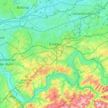
Nome: Mapa topográfico Essen, altitude, relevo.
Local: Essen, North Rhine – Westphalia, Germany (51.34757 6.89434 51.53423 7.13765)
Altitude média: 86 m
Altitude mínima: 27 m
Altitude máxima: 254 m
The lowest point can be found in the northern borough of Karnap at 26.5 m (86.9 ft), the highest point in the borough of Heidhausen at 202.5 m (664 ft). The average elevation is 116 m (381 ft).
Outros mapas topográficos
Clique em um mapa para visualizar sua topografia, sua altitude e seu relevo.
Helpenstein
Germany > North Rhine – Westphalia > Neuss
Helpenstein, Neuss, Rhein-Kreis Neuss, North Rhine – Westphalia, 41472, Germany
Altitude média: 49 m
Duren
Germany > North Rhine – Westphalia > Kreis Düren
Duren, Kreis Düren, North Rhine – Westphalia, Germany
Altitude média: 145 m
Cologne
Germany > North Rhine – Westphalia
Cologne, North Rhine – Westphalia, Germany
Altitude média: 69 m
Witten
Germany > North Rhine – Westphalia > Ennepe-Ruhr-Kreis
Witten, Ennepe-Ruhr-Kreis, North Rhine – Westphalia, Germany
Altitude média: 137 m
Herscheid
Germany > North Rhine – Westphalia > Märkischer Kreis
Herscheid, Märkischer Kreis, North Rhine – Westphalia, 58849, Germany
Altitude média: 441 m
Cleves
Germany > North Rhine – Westphalia > Kreis Kleve > Cleves
Cleves, Bedburg-Hau, Kreis Kleve, North Rhine – Westphalia, 47533, Germany
Altitude média: 35 m
Linnep
Germany > North Rhine – Westphalia > Kreis Mettmann > Ratingen
Linnep, Lintorf/Breitscheid, Ratingen, Kreis Mettmann, North Rhine – Westphalia, 40885, Germany
Altitude média: 83 m
Ruppichteroth
Germany > North Rhine – Westphalia > Rhein-Sieg-Kreis
Ruppichteroth, Rhein-Sieg-Kreis, North Rhine – Westphalia, 53809, Germany
Altitude média: 216 m
Brandenberg
Germany > North Rhine – Westphalia > Kreis Düren > Hürtgenwald
Brandenberg, Hürtgenwald, Kreis Düren, North Rhine – Westphalia, 52393, Germany
Altitude média: 324 m
Würselen
Germany > North Rhine – Westphalia > Städteregion Aachen
Würselen, Städteregion Aachen, North Rhine – Westphalia, 52146, Germany
Altitude média: 172 m
Bochum-Mitte
Germany > North Rhine – Westphalia > Bochum
Bochum-Mitte, Bochum, North Rhine – Westphalia, Germany
Altitude média: 91 m
Bottrop
Germany > North Rhine – Westphalia
Bottrop, North Rhine – Westphalia, Germany
Altitude média: 53 m
Brakel
Germany > North Rhine – Westphalia > Kreis Höxter
Brakel, Kreis Höxter, North Rhine – Westphalia, 33034, Germany
Altitude média: 232 m
Erndtebrück
Germany > North Rhine – Westphalia > Kreis Siegen-Wittgenstein
Erndtebrück, Kreis Siegen-Wittgenstein, North Rhine – Westphalia, 57339, Germany
Altitude média: 543 m
Kamp-Lintfort
Germany > North Rhine – Westphalia > Kreis Wesel
Kamp-Lintfort, Kreis Wesel, North Rhine – Westphalia, 47475, Germany
Altitude média: 28 m
Königswinter
Germany > North Rhine – Westphalia > Rhein-Sieg-Kreis
Königswinter, Rhein-Sieg-Kreis, North Rhine – Westphalia, 53639, Germany
Altitude média: 137 m