
Faça uma doação
Mapa topográfico Bernardsville
Clique no mapa para exibir a altitude.
Faça uma doação
Bernardsville
Bernardsville has a climate that borders between Humid continental and Humid subtropical with cool sometimes cold winters and warm to hot, humid summers on average. High elevations of the town have a warm summer humid continental climate with more snow during the winter and more orographic precipitation. Summer is the wettest season with frequent afternoon thunderstorms while Winter is the driest season.
Faça uma doação
Sobre este mapa
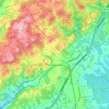
Nome: Mapa topográfico Bernardsville, altitude, relevo.
Local: Bernardsville, Somerset County, New Jersey, United States (40.69287 -74.64098 40.75800 -74.54875)
Altitude média: 142 m
Altitude mínima: 58 m
Altitude máxima: 263 m
Faça uma doação
Outros mapas topográficos
Clique em um mapa para visualizar sua topografia, sua altitude e seu relevo.
Faça uma doação
Faça uma doação
Woods Tavern
United States > New Jersey > Somerset County > Hillsborough Township
Altitude média: 28 m
Faça uma doação
Faça uma doação
Faça uma doação
Faça uma doação
North Branch Depot
United States > New Jersey > Somerset County > North Branch Depot
Altitude média: 38 m
Faça uma doação
Faça uma doação
Liberty Corner
United States > New Jersey > Somerset County > Bernards Township > Liberty Corner
Altitude média: 85 m
Faça uma doação