
Obrigado por apoiar este site ❤️
Faça uma doação
Faça uma doação
Mapa topográfico Minneapolis
Clique no mapa para exibir a altitude.
Obrigado por apoiar este site ❤️
Faça uma doação
Faça uma doação
Minneapolis
A 1959 report by the U.S. Soil Conservation Service listed Minneapolis's elevation as 830 feet (250 m). The city's lowest elevation of 687 feet (209 m) above sea level is near where Minnehaha Creek meets the Mississippi River. Sources disagree on the exact location and elevation of the city's highest point, which is cited as being anywhere from 965–985 feet (294–300 m) above sea level.
Obrigado por apoiar este site ❤️
Faça uma doação
Faça uma doação
Sobre este mapa
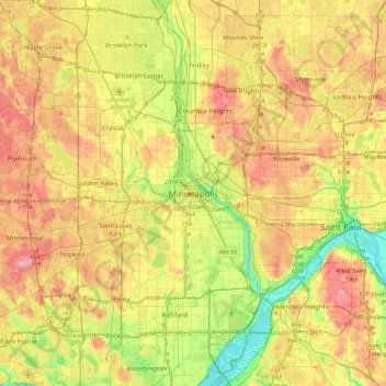
Nome: Mapa topográfico Minneapolis, altitude, relevo.
Altitude média: 271 m
Altitude mínima: 209 m
Altitude máxima: 338 m
Obrigado por apoiar este site ❤️
Faça uma doação
Faça uma doação