
Mapa topográfico Cle Elum
Mapa interativo
Clique no mapa para exibir a altitude.
Cle Elum
Cle Elum has a humid continental climate, Köppen subtype Dsb. The elevation is 1909 feet and temperatures are cooler than areas to the west. The coldest month is December, a trait common in the Pacific Northwest. But hot temperatures still occur, and not just in summer: on March 18, 1968, the temperature soared to 95 °F.
Sobre este mapa
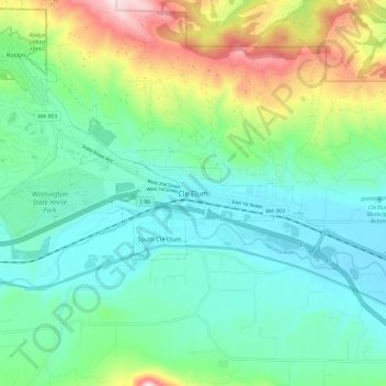
Nome: Mapa topográfico Cle Elum, altitude, relevo.
Altitude média: 697 m
Altitude mínima: 561 m
Altitude máxima: 1.066 m