
Mapa topográfico Christmas Island
Mapa interativo
Clique no mapa para exibir a altitude.
Christmas Island
Steep cliffs along much of the coast rise abruptly to a central plateau. Elevation ranges from sea level to 361 m (1,184 ft) at Murray Hill. The island is mainly tropical rainforest, 63% of which is national parkland. The narrow fringing reef surrounding the island poses a maritime hazard.
Sobre este mapa
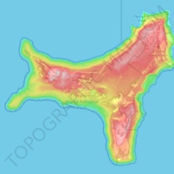
Nome: Mapa topográfico Christmas Island, altitude, relevo.
Altitude média: 69 m
Altitude mínima: 0 m
Altitude máxima: 363 m