

Mapa topográfico Shirakawa
Clique no mapa para exibir a altitude.
Shirakawa
Shirakawa is a mountain village located in far northern Gifu Prefecture, bordering Ishikawa Prefecture and Toyama Prefecture on the Ryōhaku Mountains. Mount Hakusan is the highest elevation at 2,172 metres (7,126 ft). The village's area is 95.7% mountainous forests, and its steep places are characteristic. In between the mountains flows the Shō River, which continues to the north into Nanto, Toyama. Most of the population is in its river valley. Since the opening of Hida Tunnel, Shirakawa can be reached within 50 minutes from Takayama, Gifu compared to the earlier three hour drive, and only an hour to Nanto in Toyama.
Sobre este mapa
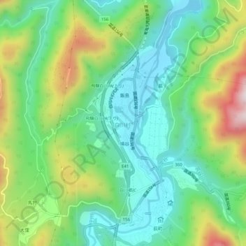
Nome: Mapa topográfico Shirakawa, altitude, relevo.
Local: Shirakawa, Ono County, Gifu Prefecture, 501-5629, Japan (36.25121 136.87867 36.29121 136.91867)
Altitude média: 667 m
Altitude mínima: 462 m
Altitude máxima: 1.095 m
Outros mapas topográficos
Clique em um mapa para visualizar sua topografia, sua altitude e seu relevo.
Shirakawa
Shirakawa is a mountain village located in far northern Gifu Prefecture, bordering Ishikawa Prefecture and Toyama Prefecture on the Ryōhaku Mountains. Mount Hakusan is the highest elevation at 2,172 metres (7,126 ft). The village's area is 95.7% mountainous forests, and its steep places are characteristic. In…
Altitude média: 1.207 m