
Faça uma doação
Mapa topográfico Al Bahah
Clique no mapa para exibir a altitude.
Faça uma doação
Al Bahah
Al-Baha is the homeland of the Ghamid and Zahran tribes and is divided geographically into three distinct parts: Sarah, which contains the high Hejaz Mountains characterized by temperate weather and rich plant cover due to relatively high annual rainfall, the Tihamah which is the lowland coastal area to the west of the Hejaz, characterized by very hot and humid weather and very little rainfall average, and the eastern hills characterized by an altitude of 1,550 to 1,900 metres (5,090 to 6,230 feet) above sea level with cool winters, hot summers and sparse plant cover. The largest city in the province, both in population and area, is Baljurashi, the second one is Al-Mandaq. In Tehama, there are two major cities: Qilwah and Al-Mikhwah. The number of tribes are 18, branching from the main ones, Ghamid and Zahran. The province has 13 settled tribes (working in trades and agriculture) and 5 nomadic tribes.
Faça uma doação
Sobre este mapa
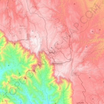
Nome: Mapa topográfico Al Bahah, altitude, relevo.
Local: Al Bahah, Al-Bahah Province, 65721, Saudi Arabia (19.85379 41.30564 20.17379 41.62564)
Altitude média: 1.744 m
Altitude mínima: 500 m
Altitude máxima: 2.553 m
Faça uma doação
Outros mapas topográficos
Clique em um mapa para visualizar sua topografia, sua altitude e seu relevo.
Biljurashi
Saudi Arabia > Al-Bahah Province > بني كبير
Baljurashi (Arabic: بَـلْـجُـرَشِي) or Biljurashi (Arabic: بِـلْـجُـرَشِي) is a city in Al Bahah Region, south-western Saudi Arabia. It is located at around 19°51′40″N 41°33′40″E / 19.8612090°N 41.5609769°E / 19.8612090; 41.5609769 in the elevation of cca 2,000…
Altitude média: 1.528 m
Faça uma doação