
Mapa topográfico Sewastopol
Mapa interativo
Clique no mapa para exibir a altitude.
Sobre este mapa
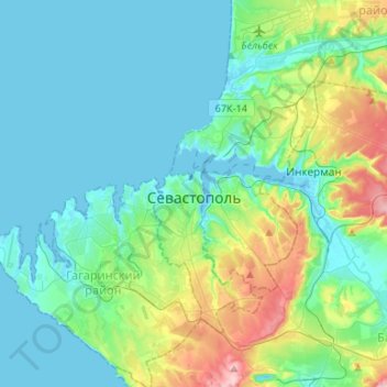
Nome: Mapa topográfico Sewastopol, altitude, relevo.
Altitude média: 68 m
Altitude mínima: -2 m
Altitude máxima: 324 m
Nicht zu übersehen ist das Denkmal für Soldat und Seemann unweit der Adler-Säule. Sein Bau zog sich jahrzehntelang (1972–1989) hin, bis die Finanzierung durch die ukrainische Regierung übernommen wurde. Die Höhe beträgt 41 Meter.
Outros mapas topográficos
Clique em um mapa para visualizar sua topografia, sua altitude e seu relevo.
Бомборы
Russland > Sewastopol > Sewastopol
Бомборы, Bezirk Nachimow, Sewastopol, Föderationskreis Südrussland, Russland
Altitude média: 56 m