
Mapa topográfico Birkenreuth
Mapa interativo
Clique no mapa para exibir a altitude.
Sobre este mapa
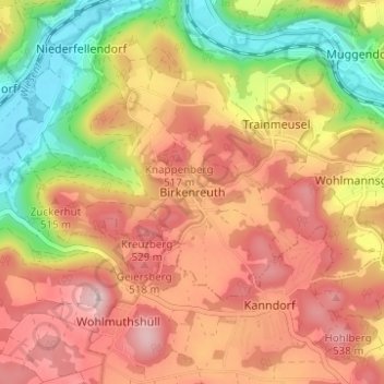
Nome: Mapa topográfico Birkenreuth, altitude, relevo.
Altitude média: 440 m
Altitude mínima: 294 m
Altitude máxima: 555 m
Outros mapas topográficos
Clique em um mapa para visualizar sua topografia, sua altitude e seu relevo.
Wohlmannsgesees
Deutschland > Bayern > Landkreis Forchheim > Wiesenttal
Wohlmannsgesees, Wiesenttal, Landkreis Forchheim, Bayern, 91346, Deutschland
Altitude média: 439 m
Trainmeusel
Deutschland > Bayern > Landkreis Forchheim > Wiesenttal
Trainmeusel, Wiesenttal, Landkreis Forchheim, Bayern, 91346, Deutschland
Altitude média: 433 m