
Obrigado por apoiar este site ❤️
Faça uma doação
Faça uma doação
Mapa topográfico A Baña
Clique no mapa para exibir a altitude.
Obrigado por apoiar este site ❤️
Faça uma doação
Faça uma doação
A Baña
Vesía is a town situated near the centre of the A Baña municipality, in the A Coruña province. It is part of the parish of San Vicente, the capital of the municipality. Vesía is at an altitude of 317.6 meters above sea level, and stands at an incline of 20.89%. Vesía has a population of around 40 people, the majority of whom are between 65 and 80 years old as the area has suffered youth emigration.
Obrigado por apoiar este site ❤️
Faça uma doação
Faça uma doação
Sobre este mapa
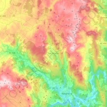
Nome: Mapa topográfico A Baña, altitude, relevo.
Local: A Baña, A Barcala, A Coruña, Galicia, 15863, Spain (42.91627 -8.84152 43.00686 -8.65624)
Altitude média: 325 m
Altitude mínima: 128 m
Altitude máxima: 516 m
Obrigado por apoiar este site ❤️
Faça uma doação
Faça uma doação
Outros mapas topográficos
Clique em um mapa para visualizar sua topografia, sua altitude e seu relevo.