
Mapa topográfico Am Schillenberg
Mapa interativo
Clique no mapa para exibir a altitude.
Sobre este mapa
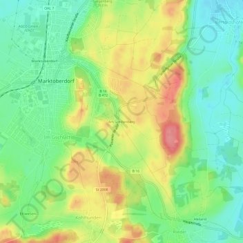
Nome: Mapa topográfico Am Schillenberg, altitude, relevo.
Altitude média: 748 m
Altitude mínima: 711 m
Altitude máxima: 800 m
Outros mapas topográficos
Clique em um mapa para visualizar sua topografia, sua altitude e seu relevo.
Mühlbichel
Deutschland > Bayern > Landkreis Ostallgäu > Marktoberdorf > Ronried
Mühlbichel, Ronried, Marktoberdorf, Landkreis Ostallgäu, Bayern, 87616, Deutschland
Altitude média: 769 m
Geisenried
Deutschland > Bayern > Landkreis Ostallgäu > Marktoberdorf
Geisenried, Marktoberdorf, Landkreis Ostallgäu, Bayern, 87616, Deutschland
Altitude média: 753 m
Bertoldshofen
Deutschland > Bayern > Landkreis Ostallgäu > Marktoberdorf
Bertoldshofen, Marktoberdorf, Landkreis Ostallgäu, Bayern, 87616, Deutschland
Altitude média: 752 m
Sulzschneid
Deutschland > Bayern > Landkreis Ostallgäu > Marktoberdorf
Sulzschneid, Marktoberdorf, Landkreis Ostallgäu, Bayern, 87663, Deutschland
Altitude média: 775 m