
Mapa topográfico Sleeping Giant State Park
Mapa interativo
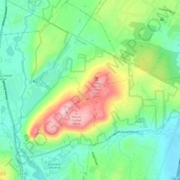
Clique no mapa para exibir a altitude.
Sobre este mapa
Nome: Mapa topográfico Sleeping Giant State Park, altitude, relevo.
Altitude média: 79 m
Altitude mínima: 5 m
Altitude máxima: 215 m
Sleeping Giant (also known as the Blue Hills and Mount Carmel), (Hobbomock in Quinnipiac), is a rugged traprock mountain with a high point of 739 feet (225 m), located eight miles (13 km) north of New Haven, Connecticut. A prominent landscape feature visible for miles, the Sleeping Giant receives its name from its anthropomorphic resemblance to a slumbering human figure as seen from either the north or south. The Giant is known for its expansive clifftop vistas, rugged topography, and microclimate ecosystems. Most of the Giant is located within Sleeping Giant State Park. The mountain is a popular recreation site: over 30 miles (48 km) of hiking trails traverse it including 5 miles (8 km) of the 23-mile (37 km) Quinnipiac Trail. Quinnipiac University is located at Mount Carmel's foot in Hamden.
Outros mapas topográficos
Clique em um mapa para visualizar sua topografia, sua altitude e seu relevo.
Lake Whitney
United States > Connecticut > South Central Connecticut Planning Region > Hamden
Lake Whitney, Hamden, South Central Connecticut Planning Region, Connecticut, United States
Altitude média: 25 m